|
|
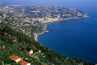
COLDIRODI
(approximate distance 4 kms.)
Piazza Europa (west side). Walk along the whole Strada Vallegrande
and take the Panoramic Climb to Coldirodi.
top
|
|
|
MADONNA DELLE PORRINE SANCTUARY
(approximate distance 2 kms.)
Piazza Europa (west side). After having covered the first part
of Strada Vallegrande, take Corso Marconi, then Strada Termini
and the entire Strada Porrine to the Sanctuary.
top
|
 |
MOTOR-RACING TRACK
(approximate distance 3 kms.)
Piazza Europa (east side). Walk along Corso Regina Margherita,
reach Via Cavour then, after having walked along Corso Marconi,
descend to the west of the town, to Corso Regina Margherita. Charming
walk with sudden and unusual scenic stretches that winds along
the hillside of Ospedaletti.
top
|
|
|
BAIA
VERDE
parcours km 2 environ
(approximate distance 2 kms.)
Via XX Settembre (east side). Through the subway, walk along the
beach down to the mooring place then continue along the shone
among gardens and little artificial hills till reach the Spring
of Sulphurous Water of Bordighera.
top
|
|
|
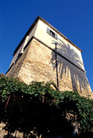
SARACEN TOWERS
Tower n° 1
Piazza Europa. By walking along part of Via Jonquière and
all along Via di Pettinengo, you reach the widening between the
central Via Roma and Via Pio VII where stands the Saracen Tower
built in 1597 (approximate distance 500 m.).
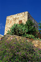
Tower n° 2
Piazza Europa (west side). After the first part of Strada Vallegrande
walk to the west, about 100 metres on Corso Marconi.
At the crossing take either:
> or Strada Noci, then walk east on Strada Punta San Pietro
> or Strada Termini and Strada Porrine then walk east on Strada
Punta San Pietro halfway of which you will see the Saracen Tower
for sighting and signaling built in 1558 (approximate distance
3 kms.).
top
|
|
|
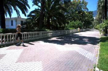
WESTERN WALK
(approximate 3 kms.)
Corso Regina Margherita (west side). Reach Strada Termini through
Gladioli Steps and Strada Punta Porrine, then descend to the coast
road Via Aurelia Ponente along Strada Costa dei Pini or Strada
Valdirodi.
top
|
|
|
EASTERN WALK
Route n° 1:
Piazza Europa. Climb Primavera Footpath to reach Viale dei Pepi,
then continue on Via delle Palme and through Carrubo Steps descend
to Corso Regina Margherita (approximate distance 2 kms.)
.
Route n° 2:
Corso Regina Margherita (east side). Through Carrubo Steps reach
Corso Garibaldi then continue east to join Strada Rotabile Capo
Nero. From here walk uphill to the old village of Coldirodi (approximate
distance 4 kms.), while, walking road you return to Via Aurelia
Levante and to the sea (approximate distance 2,5 kms.).
top
|
|
|